3D characterization of gold and copper deposits — anomalies, depths and volumes detected without a single physical drill hole.
View mining case studies →Hydrocarbon reserves remotely delineated — anticlines, trap layers and pay volumes without exploratory drilling.
View oil & gas case ↓Aquifers, water tables and deep groundwater reserves mapped from surface with depth and volume resolution.
View water case studies →When Innoson Oil & Gas secured operatorship of Block 2020a on Sierra Leone's offshore frontier — the conjugate twin of the Guyana basin — it did not have two years for a classic seismic campaign. The 4,247 sq mi (11,000 km²) survey area was characterized in a single quarter, 16 prospects and leads were identified in five clusters, and the resulting map was converted by Ryder Scott into a P50 CPR of 8.4 TCF of gas and 234 MMbbl of condensate.

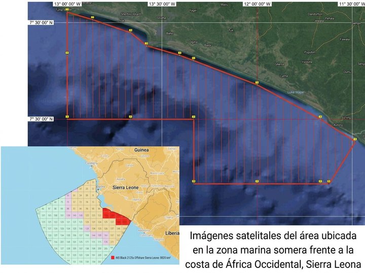
Innoson Oil & Gas Ltd —an independent operator from the Gulf of Guinea— secured operatorship of Block 2020a on Sierra Leone's offshore platform in 2020-2021. The concession covers 3,102 sq mi (8,035 km²) in waters from 1,970 to 3,280 ft (600 to 1,000 m) deep, on a passive Atlantic margin that tectonic reconstruction allows to fit precisely with the Guyana basin —where 9 Bbbl of reserves have been confirmed and up to 15 Bbbl are projected.
The Inside Earth program covered an 4,247 sq mi (11,000 km²) survey area —the block plus a margin fringe— with a 3-month lead time. The methodology combined three ERS (Earth Remote Sensing) stages: multiband satellite reconnaissance, NMR delineation processing, and a DHI deep-sounding field survey. Ryder Scott Company (Houston) acted as independent technical advisor and issued the CPR for prospective resources.
Two decades ago, the major hydrocarbon discoveries in West and Equatorial Africa redirected exploratory attention toward the conjugate margins of the South Atlantic. The Guyana basin, off northern South America, has become one of the most prolific basins in the world: 9 Bbbl of confirmed reserves and a satellite potential estimated at up to 15 Bbbl.
Sierra Leone, with more than 249 mi (400 km) of Atlantic coastline, can be tectonically reconstructed to fit precisely with the Guyana basin. It is, geologically speaking, its eastern twin — with stratigraphic and structural analogues that support first-order exploratory interest.
The Sierra Leone offshore is well covered by 2D and 3D seismic and confirms a mature petroleum system in the deep section. The challenge was not regional prospectivity, but block-level characterization: identifying where, at what depth, and with what fluid the reservoirs sit inside Block 2020a.
Data shown is for illustrative purposes.
Innoson Oil & Gas set the program with three conditions: cover 4,247 sq mi (11,000 km²) in a single pass, keep the lead time to roughly one quarter, and rely on Ryder Scott's independent audit over the resulting volumes.
A three-stage ERS workflow was executed: multisensor satellite reconnaissance, NMR delineation processing, and a DHI deep-sounding field survey over the anomalous zones. Integration with legacy seismic allowed Innoson to purchase only 621 mi (1,000 km) of 2D lines (out of the 2,485 mi / 4,000 km available), focused over the already-delineated anomalies.
The result was a complete characterization of the block — 16 prospects and leads in 5 clusters: Sena, Lauda, Piquet, Fangio, Jupiter — with average reservoir top at -8,860 ft (-2,700 m) TVDSS, thicknesses of 591 to 787 ft (180 to 240 m), and traps of tectonic-stratigraphic origin.
The ERS workflow applied to Block 2020a is sequential: each stage qualifies or discards the next, and each stage adds an additional layer of information about the HC anomalies. Seismic investment and drilling decisions are taken at the end, on bidirectional remote + seismic evidence.
Time series, multispectral and hyperspectral imagery processed to extract spectral reflectance, identify elements, and detect processes —including signs of tectonic faults— using visible, ultraviolet, infrared and radar over 4,247 sq mi (11,000 km²). This stage qualifies or disqualifies the area for further investigation.
Qualifies the areaThe high-resolution multisensor dataset is processed to filter noise and amplify anomalous signals indicative of hydrocarbon accumulation. Delineation accuracy is achieved through proprietary radiation treatment of analogue imagery and the nuclear magnetic resonance (NMR) signature of the sample resource. Output: 5 anomalous clusters · 16 prospects/leads.
Delineates and ranksNMR processing over the multisensor imagery revealed five clear anomalous zones inside Block 2020a. Legacy seismic acquired only over those zones confirmed the anomalies as bright spots and provided the structural geometry of the traps.
Beyond the polygon coordinates, no oil samples, chemical composition data or well information were provided. Image processing and NMR nevertheless identified five clear anomalous groupings —Sena, Lauda, Piquet, Fangio, Jupiter— accounting for the 16 prospects and leads on the block.
Schematic plan view of the block with the 5 anomalous clusters (proxy representation). Color codes the dominant fluid by cluster.
The anomalies guided the selection of legacy 2D seismic lines crossing the zones. Instead of acquiring the full ~2,485 mi (~4,000 km) dataset, Innoson purchased only 621 mi (1,000 km) over the anomalous zones — a 75% reduction in seismic area with equivalent interpretation.
Structural interpretation over those lines revealed traps of tectonic-stratigraphic origin. Velocity analysis confirmed the NMR anomalies as bright spots, and pre-stack Kirchhoff migration showed the gas-fluid contact and the local interval-velocity drop predicted.
| Trap type | Tectonic / Stratigraphic |
| Area (one of the traps) | 68.7 sq mi (178 km²) |
| Water depth | 1,970 — 3,280 ft (600 — 1,000 m) |
| Reservoir top (TVDSS) | -8,860 ft (-2,700 m) average |
| Reservoir thickness | 591 — 787 ft (180 — 240 m) |
| Structural amplitude | 4,790 ft (1,460 m) |
| Acquired seismic | 621 mi (1,000 km) · 75% less |
Three-dimensional reconstruction of the 16 prospects and leads identified by Inside Earth and certified by Ryder Scott (CPR January 2022). The five groupings —Sena, Lauda, Piquet, Fangio, Jupiter— sit around the average reservoir top of -8,860 ft (-2,700 m) TVDSS, with documented thicknesses of 591 to 787 ft (180 to 240 m) and a structural amplitude of 4,790 ft (1,460 m). Colored by dominant fluid. Z axis exaggerated ×8 for legibility.
Data shown is for illustrative purposes.
On the findings delineated by Inside Earth in Block 2020a, Ryder Scott Company —an independent petroleum consulting firm operating since 1937 and widely relied upon for reserves certification— issued in January 2022 the Competent Person Report on prospective resources attributable to the concession.
Ryder Scott's Competent Person Report confirmed the 16 prospects and leads identified, organized into the five clusters —Sena, Lauda, Piquet, Fangio and Jupiter— and issued the P50 (median) estimate of prospective resources attributable to the offshore Sierra Leone licensee.
The document, dated 1 January 2022 and signed by Stephen T. Phillips, Tosin Famurewa and Olga Logvinova, places the inventory at 8.4 TCF of gas and 234 MMbbl of oil in the median-case scenario for recoverable resources. It is the technical document of record sustaining the block's current farm-in negotiations.
With the gas and condensate inventory certified by Ryder Scott already closed, the ERS Field Survey (DHI) stage was executed over the clusters likely to contain oil. NMR deep sounding, supplemented by point EM measurements, revealed an aggregated oil volume in the prospective resource category above the pre-survey estimate.
Aggregated oil volume in prospective resource category identified by the DHI study over the two lead clusters Fangio and Jupiter on Block 2020a.
DHI (Direct Hydrocarbon Indicator) is the ERS III method: resonance-frequency-modulated waves that trigger a unique NMR response from the target at depth, picked up by surface receivers. This is the stage directed at reducing dry-hole risk.
The client started from an assigned area of more than 3,089 sq mi (8,000 km²), an estimated exploration term of two years, and a seismic acquisition cost above 5,000 USD/km. Integrating the Inside Earth workflow compressed all of those variables at once.
Seismic acquired only over IE anomalous zones — 621 mi (— 1,000 km) of 2D lines instead of the 2,485 mi (4,000 km) available in the dataset.
3-month lead time to characterize the 4,247 sq mi (11,000 km²), compared to the original two-year plan for a conventional exploratory program.
Combined reduction in seismic cost, lead time, and dry-hole exposure — measured against the operator's original plan for the block.
Carbon emissions avoided by reducing seismic operations and the field-program travel and logistics they require.